4.4. Mapping rules: Turkey
4.4.1. General rules
4.4.1.1. It is forbidden to draw the following on Yandex Map Editor:
-
- Military training areas, shooting ranges.
- Military commissariats, schools, hospitals.
- Buildings and other infrastructure items (structures, helicopter pads, etc.) controlled by the Armed Forces, Gendarmerie, Ministry of Defense, or National Intelligence Organization of Turkey.
- Military airfields, landing strips and the signal markings on them. Railway stations on military bases.
- Any manufacturing, technical, or administrative buildings/territories related to companies that have dealings with the military-industrial complex (Aselsan, Roketsan, etc.).
- Buildings and territories related to civil defense (shelters or other buildings used to provide safe accommodations to the civil population during a natural disaster or other emergency situation).
- Coast guard buildings (signaling structures, military lighthouses, rocket defense squadrons, etc.). Pipelines (including oil, gas and water pipes), transmission lines and other structures related to energy transmission.
- Items that mark state borders, including permanent or temporary fencing, barricades or barriers.
This ban not only concerns posting images of the items listed above and their components on Yandex Map Editor, but also entering their categories, types, coordinates, names, numbers, or other identifiers.
4.4.1.2
- Write all words (other than linking words) in names of items using uppercase letters.
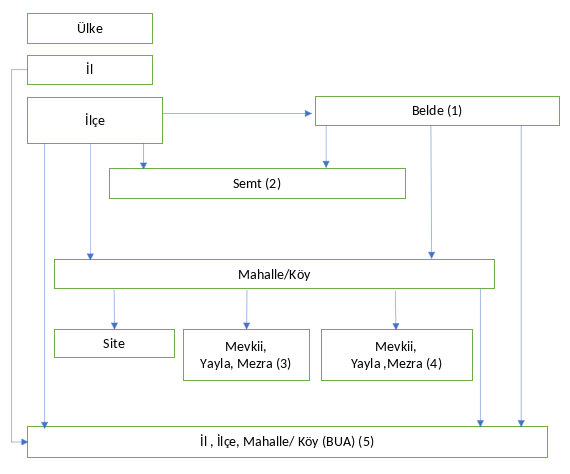
4.4.2. Administrative divisions
Levels of administrative divisions:
|
Level |
Name (Turkish) |
Note |
|
1 |
||
|
2 |
il |
Doesn't apply |
|
3 |
ilçe |
Doesn't apply |
|
4 |
Mahalle (abbr. Mah.), OSB |
OSB only with the |
|
4 |
Mevki, Mezra, Belde |
Equivalents of mahalle that are addressable (have an official status) |
|
5-6 |
Analogous to a city district, a named territory (if the named territory covers all the blocks in a development, draw it at level 4) |
|
|
6 |
Mevki |
Undeveloped territories, territories without an official status that have separate buildings under construction |
|
7 |
Organize Sanayi Bölgesi (abbr. OSB) |
OSB without the |
Write the types in official names of administrative division units for municipalities, blocks, and named territories as well as areas of development that have the same name as municipalities.
Note
You can only specify the type for "il" and "İlçe" in the "Also known as" field.
Shorten the Mahalle type for official names of administrative division units in Turkish to Mah.
The City
status can only be assigned to administrative divisions which are the centers of their respective regions (il) or district centers (ilçe).
See the picture for Turkey's administrative division borders (the administrative division level is shown in square brackets, and the bracketed number is for the corresponding note):
Note
(1) Belde is a territorial entity between a district and a locality. Items of this type are not marked as a municipality
. In our classification, this is a locality that consists of several Mahalle. They all have similar attributes.
(2) Semt is a historical territorial entity that covers multiple Mahalle. The borders are not official.
Mahalle (Mevkii), Yayla, and Mezra can be both official (3) and unofficial (4), which you can check in the information address systems.
(3) Address-forming items. Their borders are hypothetical and set as borders of development areas (BUA). Items within the development area have a center and no border. Only draw the border for the BUA of the parent Mahalle.
(4) Obsolete or unofficial items. Either their borders are set as borders of development areas, or they are drawn as places.
(5) BUA is a development area. They are drawn:
- For all il.
- For İlçe that are not part of the development area of an il.
- For Mahalle that are not part of the development area of an il or an İlçe. Have the same information attributes (name, population) as their parent items.
There are no Belde in metropolitan areas, and items of the Yayla, Mevki, and Mezra type can only be mapped as administrative divisions of the Named territory
category.
If İlçe-type items have no residential area with the same name, draw the center of the administrative division in the center of the locality it belongs to and not in the İlçe's geometric center.
For the rules for translating the names of administrative division types in Turkey into Russian and English, see Appendix 3.2.
4.4.3. Buildings and addresses
4.4.3.1
-
It is preferable to draw the address point closer to the edge of the building:
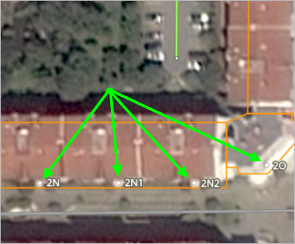
If an object from the
Locations
category overlaps with an address point, it's preferable to move the address point rather than the organization point to remove the overlap. At the same time, move the address point deeper into the building so that it remains on the same axis as its corresponding entrance and doesn't cross the middle of the building.Correct
Incorrect
4.4.3.2
- If the address of a residential building only has one associated entrance, don't name the entrance.
4.4.3.3
-
Apartments and blocks are created at address points. Additionally:
-
if the name of the apartment or building block belongs to the same parent object as the house number, it is added to the existing address of this building as the type name.
synonym
; -
If blocks and apartments belong to a different parent object, they are created as an additional address point of the parent object for the block or apartment.
-
Using a space when writing names of apartments and blocks that contain a letter (such as C Blok) is allowed.
-
4.4.4. Roadways and road infrastructure
4.4.4.1
-
The type in the name of the road in Turkish is written abbreviated (if there is a common abbreviation, see below), the full version can be added as the type name.
synonym
. The proper name of the road is always written at the beginning, type ─ at the end of the name.Translate the
Yanyol
type asfrontage road
. Such roads should be assigned the Frontage road attribute. 3.3.2.7. Design features.Use abbreviated names for the following types of roads:
Name
Abbreviation
Translation
Sokak
Sok.
street
Cadde
Cad.
street
Bulvarı
Bul.
boulevard
Çıkmaz
Çk. Sok.
dead end
Note
If there are streets of the same name with the
Cadde
andSokak
types on the map,Cadde
is translated asпроспект
.
4.4.4.2
- All roads are linked to whatever division of level 4 or higher completely encompasses them within the smallest possible area. Furthermore, level-4 roads are only linked to administrative divisions that are Municipalities.
4.4.4.3
- Intersections and interchanges with proper names are classified as the
named exit
road type (see 3.3.3.2. Type of road
4.4.4.4
-
Numbers in street and road names are considered ordinal numbers and should be followed by a dot.
For example: 123. Sok.
Note
Dates are an exception and shouldn't be followed by a period in names.
The term
Nolu
in the name replaces the period. For example, 120300 Nolu Sok.
4.4.4.5
- If road names are the same, set them using the format used in official sources.
4.4.4.6
-
Speed limit signs that are installed on the right side of the roadway before additional lanes for exiting the main road and aren't duplicated on the left side of the road apply only to those road sections and don't extend to the main road:
Start of the lane:
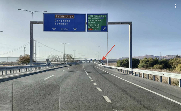
Sign placement:
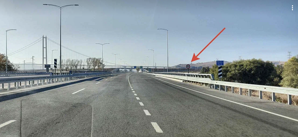
The speed limit is set according to the value indicated on the sign, even if this value is not a multiple of 5.
4.4.4.7
- One-way traffic is assigned to class 7 and 6 roads if there are road signs on the ground that restrict entry or turns to this road from one of the sides.
4.4.4.8
-
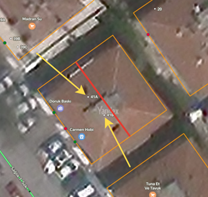
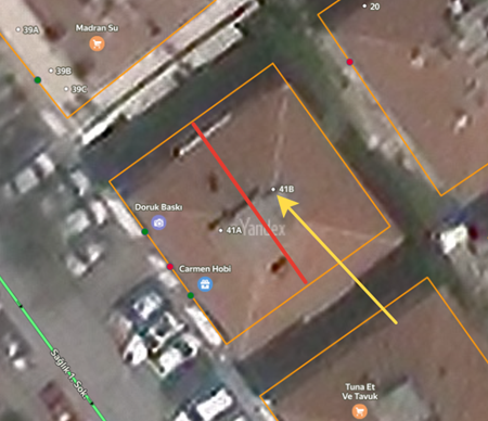
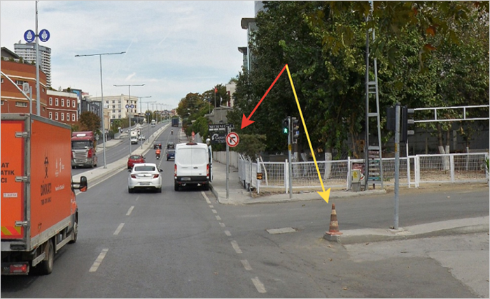
No-turn signs located immediately after the intersection prohibit the specified turn at that intersection.
For example, in the picture below, the red arrow marks a sign prohibiting a right turn, and the yellow arrow points to the road onto which the turn is prohibited by that sign.
4.4.4.9
- On pedestrian roads, it is preferable to restrict access to cyclists.
4.4.5. Transportation
4.4.5.1
- In addition to the proper names of stops, enter the operator that services them for all types of transport.
4.4.5.2
-
Metro station names include:
-
Official — the line where the station is located and the proper name and type of the station.
-
For caption — the line where the station is located and the proper name of the station.
-
4.4.5.3
- Exits from metro stations in Turkey can include the word
Entrance
in their names, even if the exit doesn't have an official name.
4.4.6. Locations
For many organizations, the item type is an integral part of their name and they use it on their signs. In such cases, the item type is included in the official name. For example: Opet Ultramarket.