3.3.3. Road attribute rules
Roads on Yandex Map Editor are composite linear items that are not drawn on the map, but rather compiled from one or more road sections, each of which is drawn individually and assigned separate attributes. For more information, see 3.3.2. Rules for adding attributes to sections of road.
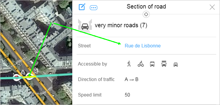
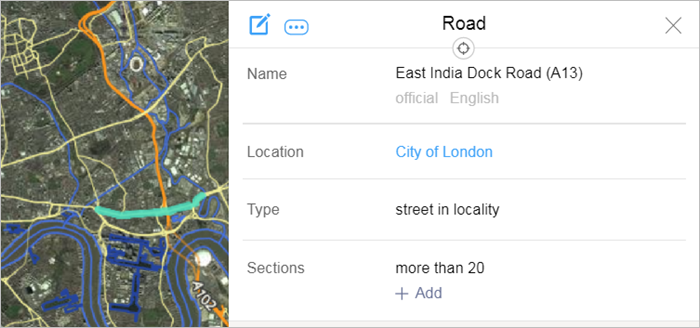
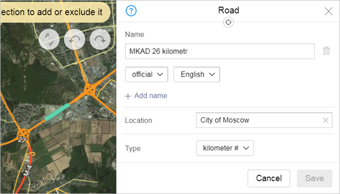
Roads are created as individual items when you fill in the Street field in the attribute panel for a road section. For more information, see 3.3.2.2. Street. After you create the road, its name will appear as a link in the attribute panel for that road section.
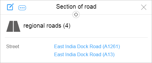
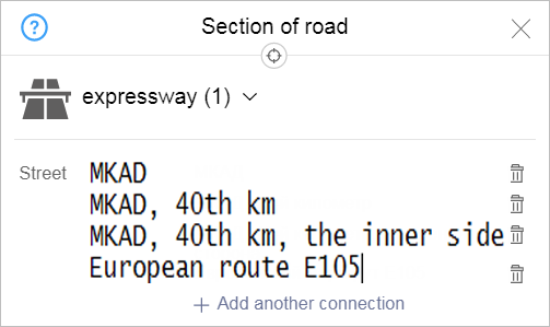
If the road section belongs to several streets simultaneously, then several links will appear:
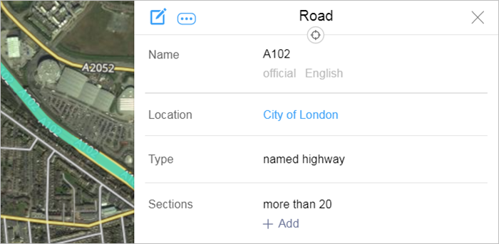
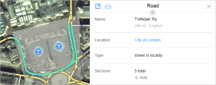
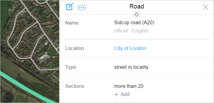
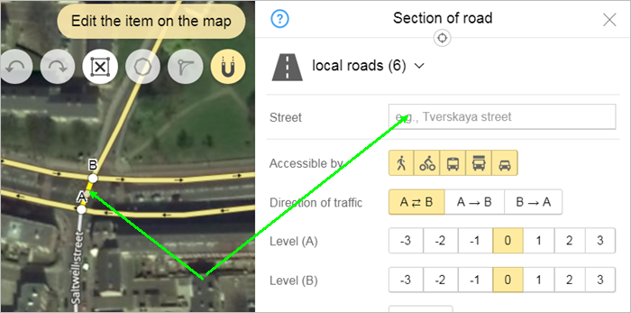
The road's attribute panel will open when you click on the link. Click  (Edit) to switch the panel to editing mode:

Use the panel to add attributes to the road.
Techniques for adding attributes to road sections are similar to the techniques for adding attributes to all items on YME.
When you name a road drawn using two lines, the name applies to both lines.
Here is a list of attributes for Road items and rules for assigning values to them.
3.3.3.1. Location
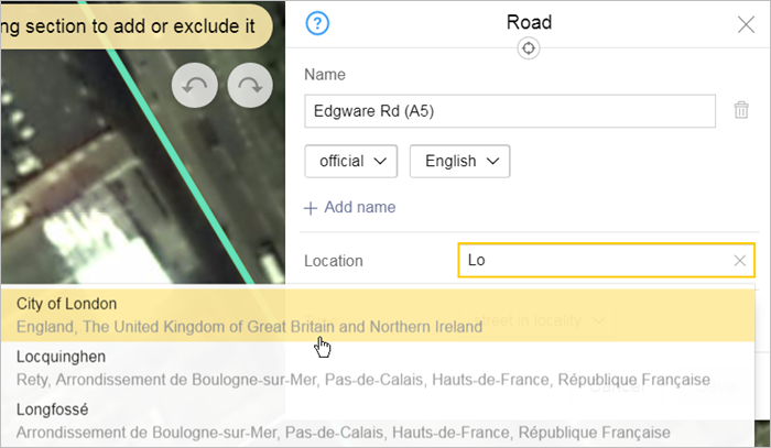
The Location attribute determines how roads are linked to an administrative division or vegetation item (if they aren't in the list of official streets of a locality and are named by the administration of the vegetation item). Unless otherwise specified in the rules for a particular road type or country, link a road to level 4 (or higher) administrative division that fully covers it.
As you enter the name of the administrative division or vegetation item into the field, a list of suggestions comprised of items already on the map and whose names include those characters will appear automatically:
When linking a road to an administrative division:
- 3.3.3.1.1
-
International motorways split into sections at state borders and each section belongs exclusively to the country that it runs through.
Each piece of road connects to its corresponding first-level (“Country”) administrative district.
- 3.3.3.1.2
-
Interstates (as well as federal routes in Russia, which include branches of the main road) are considered first-level administrative divisions (“Nationwide”).
Regional and inter-municipal highways are attributed to second-level administrative divisions (“Region”). If there are no regions, the road is attributed to the largest third-level administrative division (“District”) that fully covers the highway. If there are no districts, it is attributed to a first-level administrative division (“Country”).
- 3.3.3.1.3
-
Roads of regional significance and inter-municipal roads are linked to second-level (“Region”) administrative districts rather than to districts or settlements (even if the road is entirely contained within the latter).
Note. If the Yandex Map Editor rules allow mapping local roads of a given country, make sure that they're linked according to the current guidelines. - 3.3.3.1.4
-
Streets are linked to localities, except in cases where it's impossible to establish the existence of the locality to which the street belongs, or you know that the street belongs to a higher-level administrative division.
If the country is divided into municipalities and doesn't use the term “locality”(like Turkey or France), link streets to municipalities (administrative division items drawn at level 4 “Locality” with Municipality checked).
Link long streets that pass through several municipalities to higher-level administrative divisions.
If two streets in the same locality share the same name, link them to the districts or blocks where they are located according to official sources.
Note.If you can't find information about a street's location in official sources, then link the street to the district or block that it is generally considered to belong to.
A street linked to a locality should be located entirely within the borders of that locality, except in cases where the partial or complete location of the street outside the locality is confirmed by official sources. A street may partially extend beyond the borders of a locality that doesn't have an official status, provided that the majority of the street is located within the borders of that locality.
- 3.3.3.1.5
-
Race tracks, kart circuits, motorcycle race tracks, running tracks, and so on are linked to administrative divisions of the “Block” type.
To link a named sports track or an unofficial street named by an organization, create a separate administrative division of the “Block” type with the Doesn't have an official status option.
- 3.3.3.1.6
-
Ferry crossings are linked to first-level administrative divisions (“Nationwide”). Ice crossings and winter roads should be linked to second-level administrative divisions they're located in. If they're located within several second-level administrative divisions, link them to first-level administrative divisions instead (“Nationwide”).
- 3.3.3.1.7
- Kilometer counts should be linked to lowest-level administrative divisions they're located in, but not below the locality level.
- 3.3.3.1.8
-
Named exits should be linked to a parent the same way as streets.
- 3.3.3.1.9
-
When you link a road to a vegetation item, make sure it is named by the item (for example, a park) and not included in the list of official streets of the administrative division within which it is located. Otherwise, link the road to the administrative division.
3.3.3.2. Type of road
Select the road type from the list in the Type field:
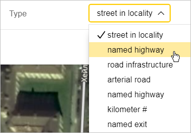
Rules for selecting a type are listed below.
- 3.3.3.2.1. Street in locality
-
All streets in localities that have the same official name (including names of ring roads and transit roads if they have the same name outside the borders of the locality) as well as streets with unofficial names used locally:
Additionally, this type includes major car-racing tracks, running tracks at stadiums and sports complexes, as well as alleys and avenues that are located in named parks or squares and mentioned in official documents.
Names are considered official if they can be confirmed by the following:
- Official sources (for example, FIAS, the Rosreestr, or official street-naming orders in Russian laws and regulations)
Local regulations or maps (for gardening partnerships, cottage settlements, parks, cemeteries, and so on).
- Maps or sites of major auto- and motor-racing tracks that host international competitions (for example, the Nürburgring or the Circuit de Barcelona-Catalunya).
Names are considered unofficial but allowed to be displayed on the map if they can be confirmed by the following:
- A map or a resolution of the administration for the organization (allowed to be displayed on the map) that named the road. For example: a market, garage cooperative, factory, or enterprise. When naming this type of road, you should create an administrative division for the parent organization with the Doesn't have an official status option and link the road to it.
An address that belongs to this street, is located inside an administrative division with the Has no official status option enabled, and is allowed to be displayed on the map.
Note. Don't add unofficial item names to road sections that are already part of official streets or other roads. - 3.3.3.2.2. Numbered highways
-
Highways with a number confirmed by a road database.
The “Numbered highway” road type is assigned to roads of the following significance:
- International highways.
- National highways.
- Roads of regional and inter-municipal significance (or roads of similar significance outside the Russian Federation).
Note. Do not map roads of lower significance (for example, local roads in the Russian Federation or rural roads in Ukraine).If the highway has a proper name in addition to the number used as part of its name (in the form of an abbreviation or capital letter), enter it using this format:
- in the official name — Full name + Abbreviated name and number;
- in the caption name — Abbreviated name and number.
For example:
In Russian In English Official name European route E95
Asian Highway 6
Interstate Highway I-32
European route E95
Asian Highway 6
Interstate Highway I-32
Name for caption E95
AH6
I-32
E95
AH6
I-32
In Russian In English Official name European route E95
Asian Highway 6
Interstate Highway I-32
European route E95
Asian Highway 6
Interstate Highway I-32
Name for caption E95
AH6
I-32
E95
AH6
I-32
 Attention.
Do not map numbered highways that are located completely within the territory of a locality.
See also 3.3.3.3.1.
- 3.3.3.2.3. Road infrastructure
-
Roads named after other structures they are related to: bridges, overpasses, tunnels (but not squares):
These items are named both as “road” items and as “road structure” items (see also point 3.8.1.2.2).
Squares are exclusively labeled as road infrastructure items.
- 3.3.3.2.4. Arterial road
-
Roads within the limits of a city or town that function as urban expressways (like the Western High-Speed Diameter in St. Petersburg) or major arterials that combine multiple streets. The last ones on some sections have official street names in addition to a single arterial road name. For example, the Third Ring Road (TTK) in Moscow, which includes Begovaya Street, Suschyovsky Val Street, and more streets, belongs to this category. So does the Garden Ring Road (Sadovoye Koltso), which includes Bolshaya Sadovaya Street, Sadovaya-Karetnaya Street, and so on.
- 3.3.3.2.5. Named highway
-
Named highways that pass through several localities as well as named ice and ferry crossings.
For example: Mozhayskoye, Borovskoye, Rublyovo-Uspenskoye Highways, Beryozovo-Deminskaya Winter Road, Plaksikha–Lubyany Ice Crossing.
- 3.3.3.2.6. Kilometer number
-
Roads whose names correspond to kilometers of named highways (for example, MKAD or Novorizhskoye Highway):
 Note.
Note.The kilometer number on the highway sign/post indicates that that kilometer ends there.
- 3.3.3.2.6.1
-
Sections of road that belong to ring roads and are marked by kilometer number can belong to one of three ring-road item types where the kilometer marking runs parallel on the external and internal sides of the ring (such as the MKAD). If the kilometer markings don't run parallel, then there are two item types for these road sections (such as the KAD, which is also known as highway A-118):
- Ring roads in general. For example, the MKAD.
- A piece of the whole road that corresponds to the kilometer in question, including both road lines. For example, Novocherkasskoye Highway, 1054th km.Attention.
Generally, address points are linked to this item.
- Two sections of road that correspond to the kilometer in question including one line of the road (along the internal and external sides).
The names of these roads distinguish between the internal and external side of the ring (using the labels external / internal side or external / internal ring).
For example, MKAD, 40th kilometer, external side and MKAD, 40th kilometer, internal side.
When specifying names used in map captions, use “km” instead of “kilometer”.
Enter the names using this format:
official name: MKAD, 40th kilometer, inner side
name for map caption: MKAD, 40 km
- 3.3.3.2.6.2
-
In the following cases, you can keep obsolete kilometer numbers, provided that the kilometer signs exist at the physical location:
- 3.3.3.2.7. Named exit
-
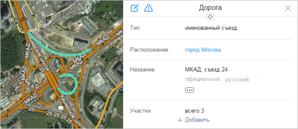
Exits from the main road that have their own names or numbers. For example, numbered exits from the MKAD (Exit 24 — exit to Kashirskoye highway).
For numbered exits, specify only the number in the caption name.
For example:
- Official name: MKAD, exit 46.
- Caption name: 46.
If the exact geometry of an exit is not known from official documents, the exit is named from its beginning to the intersection with a class 7 road (and higher).
Two or more exits with the same name located within the same locality are marked as a single item on the map.
Attention.Attribute values must not contradict each other 3.3.2.1. class and 3.3.2.7. Design features conflict with road section attributes.
For example, a “Numbered highway” cannot include sections of “Pedestrian and bike paths” or the “Roundabout” design feature.
- 3.3.3.2.8. Trails
-
Trails on Yandex Map Editor are composite linear items not drawn on the map but rather compiled from one or more sections of road, each of which is drawn individually and assigned separate attributes. For more information, see Sections 2.6.2. Composite linear items and 3.3.2. Rules for adding attributes to sections of road).
This item type is used to mark ski and tubing trails on Yandex Map Editor.
Draw these items if they meet the following conditions:
- They are official parts of sports complexes or similar items.
- They are specially designated trails (laid out specifically for training and skiing rather than running along pedestrian paths or partially passing through such paths).
- 3.3.3.2.8.1. Trail types and names
-
You can draw the following trail types:
- Ski — ski trails of varying difficulty. The difficulty level is indicated by the color and selected based on the official map of the item.
- Cross-country ski.
- Tubing.
- Snowpark — a ski trail equipped for performing tricks.
Important.Only mark the above-listed types of items as trails.
Items that don't fall into any of the categories (for example, race tracks) shouldn't be marked as trails.
Official trail names should include the name of the trail and its type assigned in accordance with the general naming rules. The “For caption on the map” name is set without specifying the type, except:
- Tubing trails and snow parks (the type is specified in the name for caption).
- Numbered trail names (the name for caption is not specified).
- 3.3.3.2.8.2. Creating trails
-
To create a trail:
Enter “Trail” in the search field (What do you want to create?) or select .
Note. You can only use the first method for the moment.The Trail panel will open.
Set the geometry of the trail by clicking on the road sections it should include (see Section 2.6.2. Composite linear items).
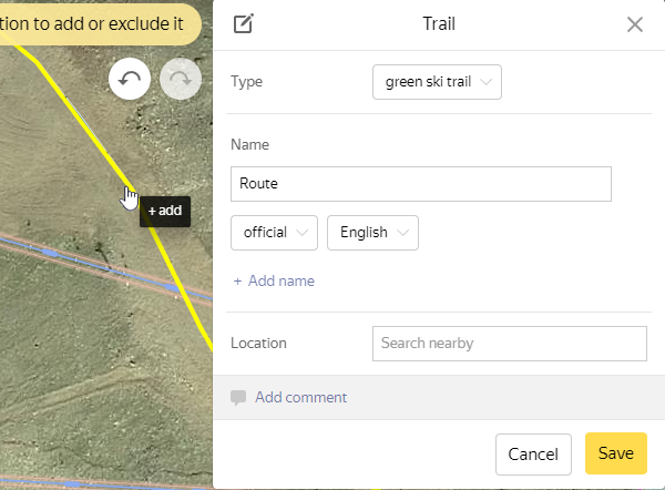
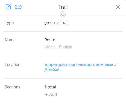
Enter the Name of the trail.
Select its Type from the list:
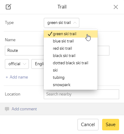
Click Save, and the trail will be saved (similar to Roads):
 Note.
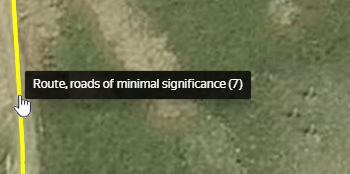
Note.Currently (before the Roads: Trails color-coding is published), trails built on the basis of a road section of a certain type are displayed on the map as a road of that type.
The type of trail doesn't affect how it is displayed, and is only shown in the tooltip:
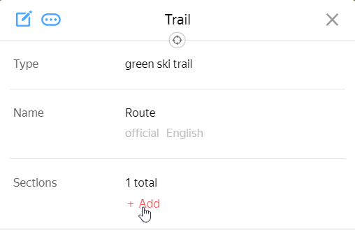
To add or create road sections based on a previously created trail, click Add in the trail card:
- 3.3.3.2.8.3. Location
-
The Location attribute determines which administrative division trails are linked to (just like with regular roads):
3.3.3.3. Road name
Enter the name of a road in the Street field of the attribute panel for that road section (this is partially shown in the drawing):
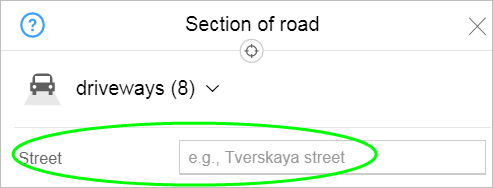
When you enter the characters that make up the road (street) name in the field, a list of streets that are already drawn on the map and whose names include those characters will display:
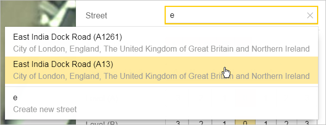
If the street is not on the map, you must fill in this field manually: enter a name for the new road and it will be created. When you enter road names, follow the Rules for naming roads (see below for information).
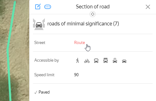
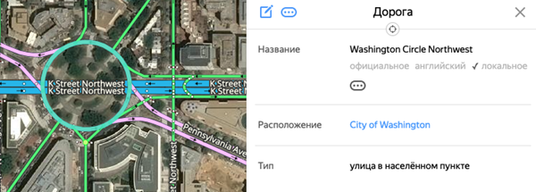
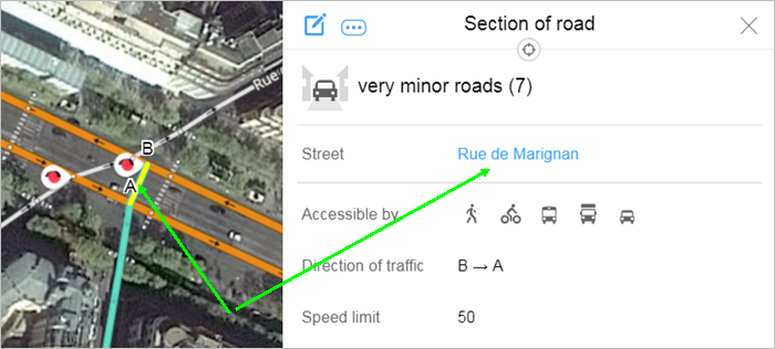
After the item is saved, its name will appear as a link in the attribute panel:
The road's attribute panel will open when you click on the link.
Click (Edit) to switch the panel to editing mode:
The techniques for entering road names are similar to the techniques for entering names for all items on YME.
- 3.3.3.3.1. Rules for naming roads
-
When you enter road names, follow the rules of grammar for the language you are using.
Note. Road naming is distinct for every country When adding road names, you should follow local norms. In particular, see 4.1.3.3. Rules for naming roads for Russia and Post-Soviet States.- 3.3.3.3.1.1
For roads that have the “# kilometer” type, you must enter a name “for caption on map” (in addition to the official name).
If that road is part of a “Numbered highway” or “Arterial road”, then the caption name for that element uses the “caption name” of the mother road (if this road is not indicated, then use the official name).
Note.If the name of such a road includes the number of kilometers written as digits, it is expressed as an ordinal number, that is, using the build-up (hyphen and letter case end).
For items whose names contain decimal fractions, separate the fraction from the integer in the official name with a dot.
For example:If this road is parent for addresses and it is written in them not in the format of a “numbered highway” (for example, 60K-11), but as a route description like “Point A - Point B” (for example, Shakhty - Tsimlyansk), then the official name should be the number of kilometers and route description and the caption name should be the highway number.- If the official name of a road is М-7 Volga, 817th km, the caption name will be М-7 (the road label M-7 Volga).
- If the official name of a road is MKAD, 73rd km, the caption name will be MKAD (the official name is the Moscow ring road, so you don't need to enter the caption name for it).
For example, if the number of kilometers is the parent item for the address “1, Shakhty - Tsimlyansk Highway, 1st km”, its name should be written like this:- Official name: Shakhty - Tsymlyansk Highway, 1st km
- For caption on map: 60K-11
- 3.3.3.3.1.2
-
Do not name exits/connecting road sections at interchanges or circular road sections except when the name of the road only refers to those sections:

Example of an exception:
- 3.3.3.3.1.3
-
If an exit has a name, enter it as the name of the road (for example, MKAD, exit 24:
- 3.3.3.3.1.4
-
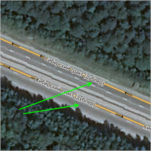
Frontage roads that run along a major city street should be assigned the same name as the main street with “frontage road” added to the name in parentheses.
Frontage roads have no unique names of their own.
Frontage roads run along major streets for several blocks.
Frontage roads start and end on the main road (not at a dead end) or a street that intersects with the main road.
If a frontage road has its own name, then add “frontage road” in parentheses to the road name (for example, Sibirsky Trakt (frontage road):
- 3.3.3.3.1.5
- The “Previously called” field is only used in cases where the name of a road changed in the past two years.
- 3.3.3.3.1.6
- The naming rules are the same for all roads, including those under construction.
- 3.3.3.3.1.7
- For roads with compound names (i.e. a road's proper name and a name of a connected road, like Sadovaya ulitsa 1-ya Liniya and Central Street Large Driveway), the names are laid out based on what sounds best in one of the approved formats. The appropriate format is chosen based on what's best for the current area and if there's not enough information, format 3 is used:
- 3.3.3.3.2
-
If a road has a very long name, then enter it as the “Official” name and use the shortened version for the “Caption” (without leaving out any of the main identifying parts of the name).
- 3.3.3.3.3. Naming highways
-
Follow these rules when naming highways (roads with the Numbered highway or Named highway type):
-
- 3.3.3.3.3.1. Highways with a number and proper name
- The numbers of highways with a number and proper name are marked on the map in accordance with official documents.
For example: M-1 Belarus (not M1 Belarus). These roads are called Numbered highways.
Enter their names using this format:
Official name — number and proper name. For example: М-7 Volga, 98K-016 Abalakh.
For roads that belong to European or Asian networks (for example, Е95 or АН6), enter two official names (in Russian and English).
You can enter an English name for a Russian highway (for example, М-10 Russia), but this is not mandatory.
Name for caption — the number without the proper name (used in the stripe on the map), for example М-7, 98K-016.
“Also known as, historical” names — description of the route that corresponds to official documentation (see 3.3.3.3.3.5), for example point A - point B.
When you enter these types of names, use a hyphen with a space on each side.
- 3.3.3.3.3.2. Highways with a number and no proper name
- Highways with a number and no proper name (typically regional highways, for example 17N-515). These roads are called Numbered highways.
- 3.3.3.3.3.3. Branches extending from federal highways
- Branches extending from federal highways are marked as items separate from the main course of the road, regardless of whether they are dead ends or transit roads. These roads are called Numbered highways.
- 3.3.3.3.3.4. Highways without a number, but with a proper name
- Unnumbered highways with their own name are roads (which do not correspond with other roads that are recorded in official documents) with assigned unique names. For example, Mozhayskoe Highway, Minskoe Highway (outside Moscow). These roads are called Named highways. They receive an official name, which is to say a unique proper name for the highway. Example: Mozhayskoye Highway.
- 3.3.3.3.3.5. Description of the route in accordance with official documents.
-
In Russia, the official documents that describe the route include the list of roads of federal significance and the lists of regional roads (by federal subject). Similar documents have been adopted in other countries.
When you use route descriptions:
- 3.3.3.3.3.6
- Enter road numbers that correspond to outdated classification systems (the USSR, RSFSR, Russian Federation classifications that remain in effect until January 1, 2018) in the “also known as, historical” field for the appropriate road.
- 3.3.3.3.3.7
-
Enter names of race tracks, motorcycle tracks, and so on if they are assigned by the sports complex. Enter them as “Official” names and indicate the type of item (for example, 5G Highway).
Ski trails and their names are created in accordance with the rules for creating trails (see 3.3.3.2.8).
You can name pedestrian paths that are only intended for athletic use and do not have proper names. For example: Ski trail.
Note.“Do not use” local unofficial (folk) names for these types of items.
- 3.3.3.3.3.8
-
You can only include road sections in several “Locality street” type objects in the following cases:
- 3.3.3.3.3.8.1
-
If a street forms the border between two localities and each side belongs to a different locality, then create two streets and link them accordingly (regardless of how the street is named). Don't enter a caption name on the map.
In these cases, the streets can have either the same name or different names.
- 3.3.3.3.3.8.2
-
If both streets are linked to the same locality, overlap each other,and only differ by number (for example, the streets on the 10th and 11th line on Vasilievsky Island in Saint Petersburg):
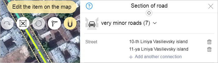
- 3.3.3.3.3.8.3
-
If both streets are linked to the same locality, overlap each other at least partially, and differ by name (for example, Luzhniki St. and Novoluzhnetsky Ln. in Moscow), then each street should be a separate item with its own official name: Caption name is not assigned.
3.3.3.4. Road components
Edit road components the same way that you would with any composite linear map item.
When you edit motorways, you can add sections of road as a group (note: this function is not available for all users).
- 3.3.3.4.1
-
The road must only include road sections that make up its main road line (no branches) and are officially deemed part of that road.
Passageways within courtyards, dead ends, or passageways between blocks in rural localities are not officially considered to be sections of roads and are thus not included in roads on maps.
All branches off the main road should not be set as parts of that road, even if they are deemed as such in official documents.
- 3.3.3.4.2
-
If there is no official information about how a section of road fits into its parent road, then place the road where the majority of addresses linked to it are located.
Additionally:
If an address point or small group of them are located at a distance from the main area with residential buildings, then you do not need to specially draw the street up to the buildings.
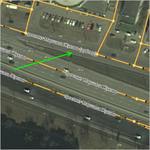
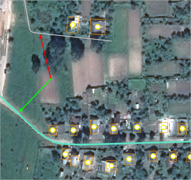
The green arrow on the drawing points to a named section of a street and the red arrow — an unnamed section of the same street:
If approximately the same number of address points are located on two streets that run parallel or perpendicular to each other, you should include both sections of road in the street.
Streets do not include passageways between the narrow sides of buildings and the courtyards except in cases when the passageway connects pieces of the same street.
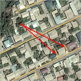
The red arrows in the drawing indicate courtyard passages that you should not include as parts of the road:
Road sections that are named based on diagrams and internal documents of parks, nature reserves, and similar items only include pedestrian sections of road.
- 3.3.3.4.3. Road components at intersections
-
- 3.3.3.4.3.1
-
If a road becomes a different road at an intersection, then the sections of those roads that are within the intersection are not considered components of the road and you should leave the “Part of” field blank:
- 3.3.3.4.3.2
-
If the road forms a T-shape at the intersection with another (two-line) road, or there are unnamed sections of road after the intersection, the section of the first road that runs through the two lines of the second road should still be considered part of the first road and share its name. This rule also applies to intersections with frontage roads.
- 3.3.3.4.3.3
-
If the same road runs along both sides of the intersection, then include the sections of road in the intersection among the parts of that road (and assign it the same name as the entire road itself):