3.14.2. Rules for adding attributes to ground transport items
Ground transport items include sections of tram lines, ground transport stops, and bus stations.
3.14.2.1. Rules for adding attributes to sections of tram lines
The attribute panel for a section of a tram line looks like this:
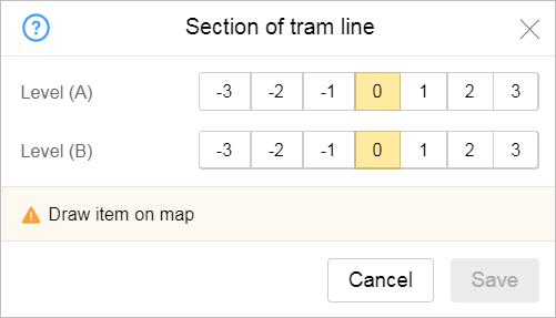
Use Level A and Level B attributes so that intersections of tram lines with other transport lines display properly when they are located on different levels (such as if one is on ground level and the other runs through a tunnel).
Enter values for the road level in the Level A and Level B fields — for the beginning (A) and ending (B) points of a line section.
- “ground level” — if the lines intersect at ground level.
- “on a bridge”, “on a bridge (+1)”, “on a bridge (+2)” — above ground level. For example, if one tram line that goes through an intersection passes over another on a bridge or as part of an interchange and the second road, railway, or tram line is at ground level.
- “In tunnel”, “in tunnel (-1)”, “in tunnel (-2)” — below ground level. For example, if one line at an intersection passes through a tunnel and the second line goes through a tunnel at a different level.
3.14.2.2. Rules for adding attributes to ground transport stops
The attribute panel for a ground transport stop looks like this:
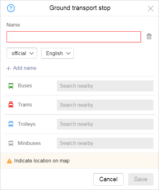
When you add attributes to a ground transport stop, follow the rules that apply specifically to them. The attributes for items are listed below, as well as the rules for entering values for each of them:
- 3.14.2.2.1
-
Names of public transport stops are set according to the rules given in the section 1.3.1. Object name: General rules and n 3.1.4.2.2 .
For public transport stops, use the name types Official, For caption on map and Also known as, historical (don't use other types of names).
Note.If there is no publicly available information about a stop's name, and you cannot pick a name based on the rules listed in this section, you can create a stop without specifying its name.
- 3.14.2.2.1.1 Official name
-
Public transport stops should use their full names with no abbreviations as official names (some common abbreviations are fine).
Make sure to use uppercase in transport stop names.
Do not use quotation marks in transport stop names.
- 3.14.2.2.1.1.1
-
Sometimes, a route passes through a locality with two stops: one inside that locality and the other on the main road as it's making a turn for said locality. If both stops share the name of the locality, they should be labeled as follows: the first stop should retain its namesake, while the second stop should say “Turn for...” before the locality's name.
Here's how this should look for a village named Kamenka:- Use Kamenka for the stop inside the village.
- Use Turn for Kamenka if the stop is a turn for the village.
If there is only one stop and it is located near the turn, it should be named in one of the following ways:- Use Kamenka if the distance between the turn and the locality is less than 1 km.
- Use Turn for Kamenka if the distance is more than 1 km.
- 3.14.2.2.1.1.2
- If a locality has several stops named after it with different numbers, do the following:
- If the name of the locality is only one word, then the number and name should be separated by a hyphen without spaces. For example: Kashino-1 and Kashino-2.
- If the name of a locality contains a number (such as Tyosovo-2) or contains more than one word (such as Belaya Kalitva), then the number used in the name of the stop and name of the locality are separated by a hyphen (we recommend using a dash) surrounded by spaces. For example: Tyosovo-2 - 2, SNT Avtomobilist – 2, Belaya Kalitva – 2.
- 3.14.2.2.1.1.3
- If a stop is named after a locality, no need to specify the locality type. However, there are exceptions to this rule, such as:
- Stops named after gardening co-operatives.
- Names where the locality type is considered a part of the proper name.
- Stops that have the same name based on different types of localities with the same name located along the route.
- Names that can be perceived as indicating the type of activity of an industrial enterprise, the military nature of an object near a locality, etc.
- 3.14.2.2.1.1.4
- If several stops share the same name in official documentation whilst also being on the same route (On demand, Gardens, etc.), you can make their names more specific (e.g. Kamenka Gardens) or you can assign names
- 3.14.2.2.1.1.5
- Do not add the name of the locality where the stop is located to the proper name of the stop except in cases when:
- It is the last stop on at least one inter-city route, but its proper name doesn't contain the name of the locality.
- The stop is located in a small locality and is the last on at least one suburban route, but its proper name doesn't contain the name of the locality.
- The official name of the stop contains the name of the locality (if there's more than one stop within this locality for which the rules allow listing the name of the locality, it is only added to the name of the main stop).
- 3.14.2.2.1.1.6
-
If a stop has no official name, you can use the name of the nearest street, a place where passengers congregate (such as a store), or any other notable landmark as a substitute.
If the official name of a stop and the name used on route signage differ, then give priority to the more commonly used name. Furthermore, all remaining station names can be added in the “also known as, historical” field.
If a stop features multiple signs with different names which are used equally often, write them in the official name field separated by slash (/).
If some of the names are much less common, only enter the most popular name in the “Official” field.
Attention.If the stop has been officially renamed, but the sign has not been updated, then enter the new name for the official name.
- 3.14.2.2.1.1.7
- In the official name for the item type, enter the transport stop name without abbreviating and in the same format that is used locally or in itineraries. Furthermore, the word order in names is determined based on what sounds best in relation to the proper name (see points 4.1.3.4.1.3 and 4.1.2.2.2.3).
If the name of a numbered item refers to an organization and is only one word long (and is not a compound word like “Caltech”), then the word order should be as follows: [type No. number].
Ordinal numbers in stop names always retain their suffixes.
For example:Local name Official name Moskovskaya St. Moscow St. North North Ln. Peredvizhnikov Peredvizknikov Ln. School #4 or #4 School School #4 Krestovsky Island metro station Krestovsky Island metro station Sportivnaya metro station Sportivnaya metro station Kryukovo station Kryukovo station Ruchi railway station Ruchi railway station 9 Maya St. 9th Maya St. Local name Official name Moskovskaya St. Moscow St. North North Ln. Peredvizhnikov Peredvizknikov Ln. School #4 or #4 School School #4 Krestovsky Island metro station Krestovsky Island metro station Sportivnaya metro station Sportivnaya metro station Kryukovo station Kryukovo station Ruchi railway station Ruchi railway station 9 Maya St. 9th Maya St. - 3.14.2.2.1.1.8
-
Rules for naming ground transport stops:
- If a stop has multiple name options, one of which is “On demand”, use the more informative name as the official name. Do not add “On demand” to it. You can enter the “On demand” name as a synonym.
- If “On demand” is the only name option, you can indicate it as the proper name for the stop (in this case, don't enter the names of other types).
- Don't name terminal public transport stops using the “On demand” name.
You do not need to add explanatory annotations to stop names (to indicate that the stop is the last one on the route or that passengers can only get on/off there).
You can only use the “End of line” marker for a last stop when it shares a name with the stop before it. In this case, the route would be Moskovskaya St. → Moskovskaya St. — End of line.
- 3.14.2.2.1.1.9
-
If the official name of a stop is an ordinal number, the stop name is written as 157 or No. 157.
If the stop also has a “popular” or historical text name (for example, Post office), the name is written as 157 - Post office or No. 157 - Post office.
If the stop has no “popular” or historical text name, you may include the street where the stop is located in its name: 157 - Belovezhskaya street or No. 157 - Belovezhskaya street.
Note.The “No.” is specified in the name of a stop if it's used together with the ordinal number in the area itself.
- 3.14.2.2.1.2 Name for caption on map
-
The "caption on map" name is only specified if it differs from the official name. For example, if there are words that should be abbreviated in accordance with the general naming rules (see Section 3.1.3.1. Name types: general rules). Caption names should match the name used on route signage as closely as possible.
You can use certain abbreviations in the name if they are used on route signage. For example: Dispatching station → DC.
Attention.Such names are not edited by users.
- 3.14.2.2.1.3 Name — also known as, historical
-
For “Also known as, historical” names, the official transport stop code can be used if it is used in passenger services (such as SMS services informing about upcoming transport). In this case, the transport stop code will usually appear on the route signage for that stop. You can also enter different variations on the proper name if they are listed in the official name field separated by slashes (“/”).
- 3.14.2.2.2 Routes
-
In the “Routes...” fields, enter the route number for each type of transport that uses that stop.
Attention.The rules for selecting, creating, and adding attributes to public transport routes can be found in Section 3.14.2.4. Rules for creating public transport routes and adding attributes to them.
Enter route numbers one at a time. They are selected from a list that automatically includes numbers of routes for every type of transport vehicle that pass through the area within two kilometers of that stop:
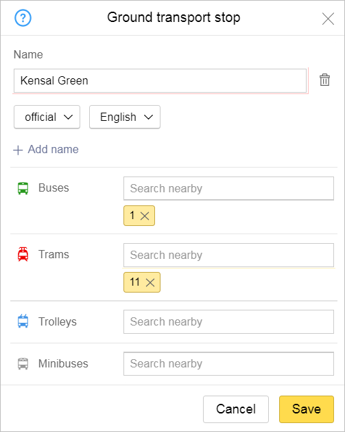
If the route number you need is not in the list, enter it in the line (this creates a new route). For map item names, write building names that are part of route numbers exactly as they are written on route signs.
The values that are entered appear in the orange stripe.
To delete a route number from a given transport stop that it no longer services, click the cross in the appropriate stripe.
To edit route parameters, click on the stripe containing the route number. For more information, see 3.14.2.4. Rules for creating public transport routes and adding attributes to them.
3.14.2.3. Rules for adding attributes to railway stations
The attribute panel for a bus station looks like this:
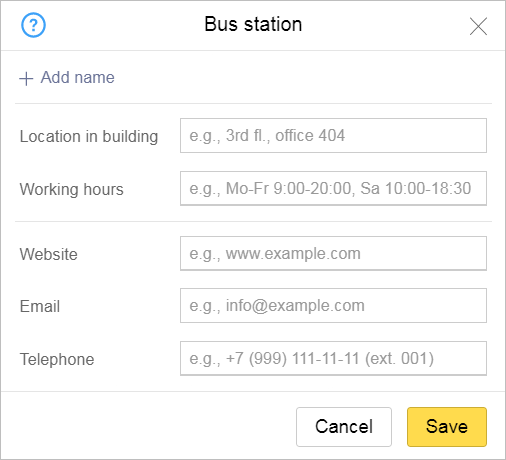
When you add attributes to bus stations, follow the rules that apply specifically to them. The attributes for items are listed below, as well as the rules for entering values for each of them:
- 3.14.2.3.1
-
Name of item:
- Is set in accordance with the general rules (see 3.1.3.1. Name types: general rules).
- Is set in accordance with the rules specified in Section 3.1.4. Forbidden locations.
- Items of this type are displayed on the map along with their type (therefore you should not enter a name in the “For caption on map” field). Furthermore, the official item name will appear on the map (for example, Soligorsk Bus Station).
- 3.14.2.3.2
-
Location in building: do not duplicate the address of the building (see Section 3.5.2. Rules for adding attributes to addresses). Indicate the location of the organization in the building.
- 3.14.2.3.3. Working hours
-
Enter the days of the week and times when the business or organization is open. For example: “Weekdays 9:00-20:00, Sat 10:00-18:00”.
- 3.14.2.3.4. Website
-
- 3.14.2.3.4.1
-
You can enter website addresses with or without the “http://” part.
- 3.14.2.2.4.2
-
You can enter the following in the “Site” field:
- Address of map item's official site
- Address of unofficial map item site (if there is an official site, then enter the unofficial site after it)
- Link to a reliable article about the item (for example, in Wikipedia)
- Link to schedule
- 3.14.2.3.4.3
-
In the “Site” field, you should not enter the item author's address or any other addresses that do not relate to the item itself.
- 3.14.2.3.4.4
-
In the “Site” field, you can enter several addresses separated by commas.
- 3.14.2.3.5. Website
-
You must enter the bus station's email address in the “Email address” field.
You cannot enter the email address of the item's author or other addresses that don't relate to the item itself.
- 3.14.2.3.6. Telephone
-
- 3.14.2.3.6.1
- Enter a map item's phone number using this format:
- +A (BBB) CCC-CC-CC
-
where:
“А” – country code (1-3 digits)
“ВВВ” – city or zone code, including for cellular numbers (this may not always be a three-digit number)
“CCC-CC-CC” – phone number (the number of digits may not always be seven).
Examples of correct number formats: +7 (495) 222-22-22, +7 (34111) 2-22-22.
- 3.14.2.3.6.2
-
You must enter the organization's phone number in the “Telephone” field.
- 3.14.2.3.6.3
-
You can not enter the number of the item's author or any other numbers that don't relate to the item itself in the “Telephone” field.
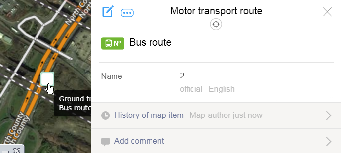
3.14.2.4. Rules for creating public transport routes and adding attributes to them
Rules for creating public transport routes are described above (see point 3.14.2.2.2 Routes.
To edit route parameters, click on the stripe containing the route number in the attribute panel for that ground transport stop.
An attribute panel for the motor transport route opens (or a similar panel for adding attributes to tram routes):
- 3.14.2.4.1. Selecting public transport routes
-
The map should have scheduled routes for all kinds of urban, suburban, and intercity land transportation, such as buses, trams, trolleybuses, and minibuses.
Urban, suburban and intercity routes come first. After most of them are complete, you can then draw the interregional and interstate routes they comprise.
You can map the following:
Seasonal and other regular routes that do not operate year-round. Route options must include their actual work schedule
Chartered public urban and suburban routes (such as routes to shopping centers)
Other available ground transport routes that carry passengers on a regular basis.
Do not map the following:
Irregular routes
Routes that aren't currently in operation, including routes featured in official registers. If a route's exact start date is known in advance, add it to the map two days beforehand
- Chartered urban and suburban routes that are not accessible to the public (such as corporate shuttles, service vehicles, or chartered tourist minibuses).
Even if the same route is serviced by different transport providers and/or types of vehicles with varying passenger capacities, you should only create one“Route” item on the map. You should only create different independent routes if the various carriers follow different itineraries or the routes have different names.
Hide (unpublish) existing routes that stop operations.
The decision to remove routes from the map is made by the service staff.
- 3.14.2.4.2. Components of public transport routes
-
After you enter the route attributes, you should link them to the transport stops where the vehicle stops (going in order in both directions). Be sure to include stations where passengers only embark or only disembark.
Note.Equipped stops in rural areas are included in all suburban and inter-city routes that pass through them (except for cases when the vehicle does not stop there).
Do not include stations where the vehicle passes by but does not stop.
To include or exclude a stop from a route:
Click Edit
 in the route's attribute panel.
Stops that are already included in the route will be marked
 .
.Click on the stop icon to include it in the route or exclude it from the route if it was included earlier:
- 3.14.2.4.3. Rules for adding attributes to public transport routes
-
When naming public transport routes, only use the “Official” and “Also known as, historical” name types. Don't use other types of names.
Note.Don't enter old route numbers or names of carriers in the route attributes.
