3.16.1. Rules for drawing water transport items
Water transport on the map is represented by sections of water transport lines, stations, and routes.
3.16.1.1. Rules for drawing sections of water transport lines
When drawing water transport line sections, you must adhere to the following rules:
- 3.16.1.1.1
-
Water transport lines (routes) are drawn for the following route types:
- Regular passenger routes, including seasonal routes.
- Ferry crossings that carry “foot” passengers.
- Other existing water transport routes that carry passengers on a regular, scheduled basis.
- 3.16.1.1.2
-
Draw water transport lines (routes) as close to actual ship routes as possible.
When drawing water transport lines (routes), you can use open sources like nautical atlases and pilot guides.
The maneuvers of ships near berths and piers (for example, to dock against the current) and the movements of ships on different sides of channels should be averaged.
If route trajectories vary depending on the day or time of day, choose the most frequent one.
Showing routes going in different directions using different sections of water transport lines is only allowed in exceptional cases when there is reliable information about the regular movement of direct and return routes along different trajectories. Only employees can do that.
- 3.16.1.1.3
-
Water transport lines are drawn in accordance with 2.6.1.1.1. General rules for drawing linear items.
- 3.16.1.1.4
-
In rare cases, service areas for water transport lines are placed near the stations. Such areas create a circle used to properly maintain route options of water transport.
Only users with access rights to editing route options can draw service areas (see section 3.14.3. Rules for creating public transport route options and adding attributes to them).
- 3.16.1.1.5
-
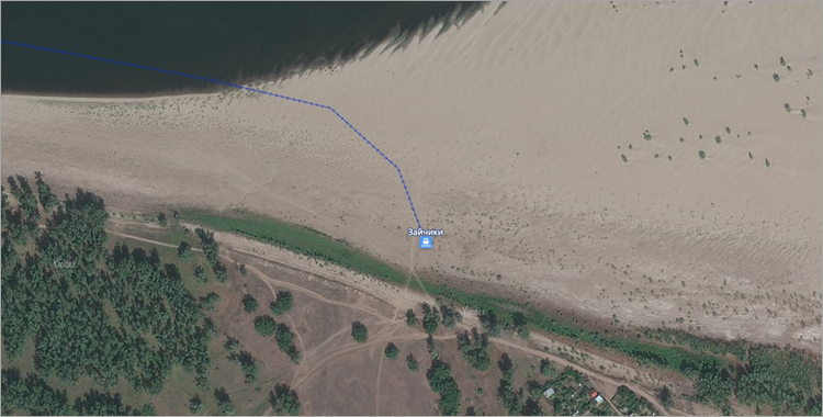
Route lines should not pass through islands, shoals, or other sections of land except for routes operating during high water or high tide.
For example, Volgograd – Zaychiki, Arkhangelsk – Patrakeevka:
3.16.1.2. Rules for drawing water transport stations
In this section:
- 3.16.1.2.1. Mapping piers and other mooring structures
- 3.16.1.2.1.1. Mooring walls
- 3.16.1.2.1.2. Mooring pontoons and landing stages
- 3.16.1.2.1.3. Piers
- 3.16.1.2.1.4. Unequipped piers and landing sites for water transport routes
- 3.16.1.2.1.5. Multiple passages to the ship
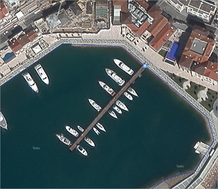
- 3.16.1.2.2. Mapping yacht clubs, boat parkings and stations, and marinas
- 3.16.1.2.3. Mapping ports, river-boat stations, and marine terminals
- 3.16.1.2.1. Mapping piers and other mooring structures
-
Water transport stations of the Pier type include piers, docks, mooring walls, mooring pontoons, yacht clubs and marinas, boat parking and stations, unequipped piers, and landing sites for water transport routes as well as landing stages that function as piers.
Water transport stations of the Pier type can represent each individual pier or a group of piers.
Individual piers are mapped in the following cases:
- The pier or berth is of transport importance (part of water transport routes).
- The pier or berth is part of a port, river-boat station, or marine terminal and has a proper name or number that confirmed locally or by schedules and schemes (and not used exclusively in official documents).
- The pier or berth is of historical significance or considered a tourist attraction.
- The pier is equipped with a landing stage.
- The pier or berth is a free-standing structure, and there are no other piers or berths nearby.
In other cases, the pier icon indicates a group of items:
- Pontoons, piers, berths, and landing stages that belong to yacht clubs, boat parkings, and marinas are drawn as a group of piers representing the yacht club, boat station, parking lot, or marina.
They are not marked as separate piers even if they have a locally confirmed name and number at the yacht club, boat station, parking lot, or marina.
All other mooring structures, walls, pontoons, bridges, and piers that don't have proper names and are located close to each other along the coastline (including piers and berths located within the territory of ports, river-boat stations, and marine terminals if their proper name or number can't be determined).
Those piers and berths are mapped in groups of up to ten items. The placemark is drawn in the center of the group, on the largest or most significant pier or berth. You can edit the group based on the potential or actual affiliation of piers and berths to certain organizations.
Note. Named piers can also represent groups of items. In that case, you don't need to create new piers.
Attention. The following structures are not marked as piers:- Piers, berths, and pontoons on privat property inaccessible to unauthorized people:
- Houseboats and floating saunas:
Yacht clubs, boat parkings, and stations if they don't have mooring facilities:
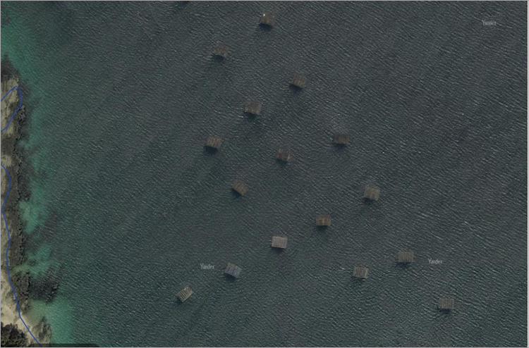
Other floating structures, including ships that don't have a pedestrian connection to the shore even if they are permanently parked.
For example, oyster farms, oil platforms, rafts and their parking areas, floating workshops and stores, dredgers, and similar structures:
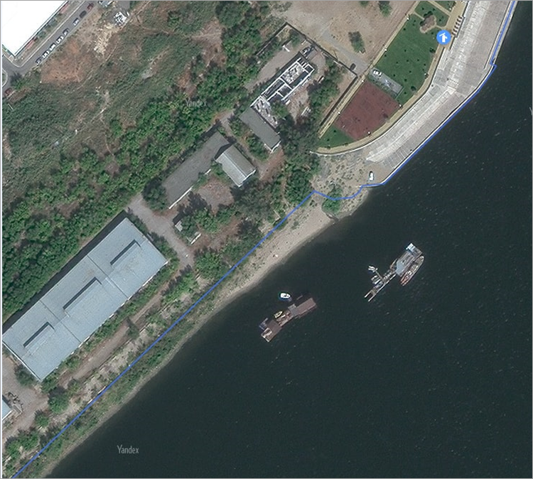
When mapping non-stationary items, keep in mind that they might be removed after the end of the navigation period. In the inter-navigation period, they might be moved to ship repair yards, fleet repair and maintenance bases, and other berthing locations. If an item is always located in the same spot during the navigation period, don't remove it from the map for the inter-navigation period. Don't map items moved to berthing locations for the inter-navigation period.
Item mapping depends on the structure type:
- 3.16.1.2.1.1. Mooring walls
-
If ships are moored directly to the mooring wall, the pier icon is placed on the hydrography border approximately in the center of the wall:
- 3.16.1.2.1.2. Mooring pontoons and landing stages
-
If ships are moored to a pontoon or landing stage, the pier icon is placed on the hydrography border at the beginning of the pontoon bridge leading to the pier:
- 3.16.1.2.1.3. Piers
-
- For piers built on stilts above the water surface,
the icon is placed on the hydrography border at the beginning of the pier in the middle of its width:
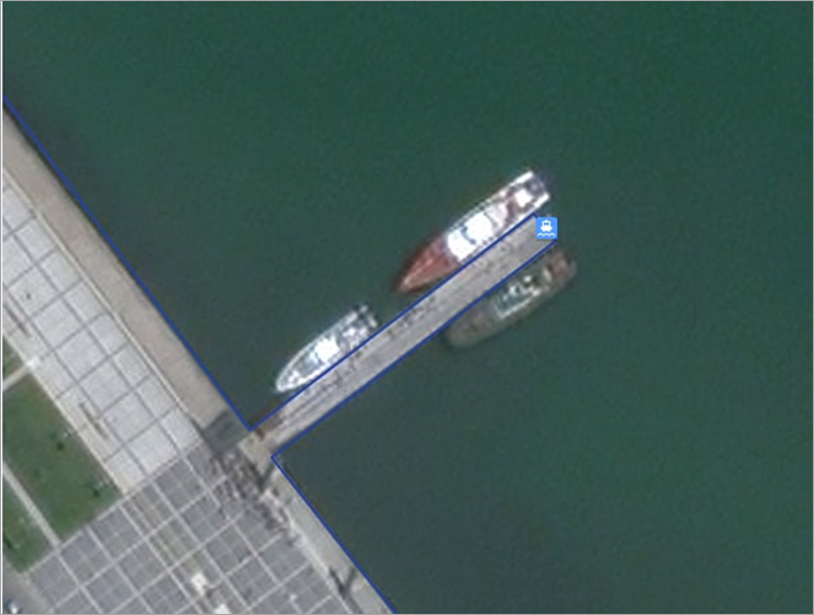
- For piers that are solid structures (artificial land extensions) protruding into water,
the pier icon is placed at its farthest end from the shore.
Pier sections are mapped according to the same rules used for the regular coastline.
Important. When mapping, make sure not to confuse piers with moles and other hydro-technical structures. Moles are hydro-technical structures built to protect ports from waves and usually not intended for mooring ships. With that said, the inner wall of the mole might be used for mooring ships in small ports. In such cases, the item should be a mooring wall. - 3.16.1.2.1.4. Unequipped piers and landing sites for water transport routes
-
Unequipped piers are drawn at the actual drop-off/pick-up spot on the hydrography border.
- 3.16.1.2.1.5. Multiple passages to the ship
-
If there are multiple passages to the ship from the shore (for example, for embarking and disembarking passengers or for different water levels), the icon is placed at the passage most frequently used by embarking passengers throughout the navigation period. No other passages are marked with additional pier icons.
The same rule applies if a ship is moored to one structure while passengers embark and disembark using another.
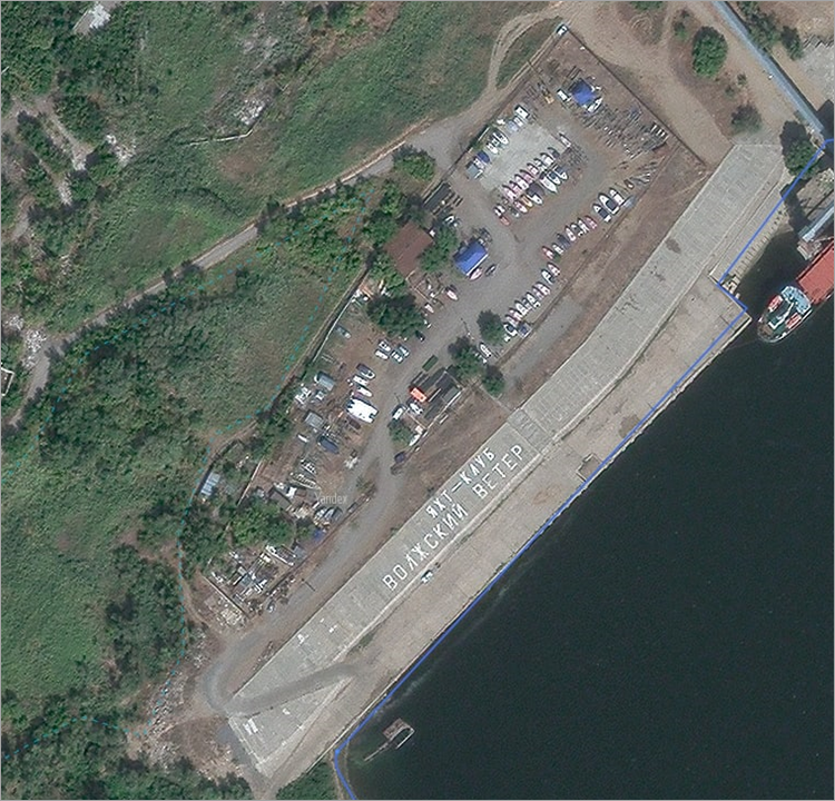
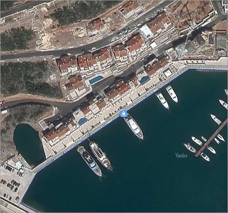
- 3.16.1.2.2. Mapping yacht clubs, boat parkings and stations, and marinas
-
These items are mapped following the “one organization — one icon” rule. If you can't tell if an item is affiliated with a particular organization, all piers located close to each other should be considered as belonging to one organization until their affiliation is determined.
The icon is placed at the common entrance point to piers, berths, and pontoons on the hydrography border. If each pier and pontoon has a separate entrance, map the entrance to the largest pier or pontoon. If you can't determine the largest pier, place the pier icon on the hydrography border approximately in the center of the berthing area.
- 3.16.1.2.3. Mapping ports, river-boat stations, and marine terminals
-
The port icon should not overlap the address point.
The icon is placed on the main control building, control tower, and so on.
If there is no control building or tower, or it is impossible to determine their exact location, the pier icon is placed on the main administration building provided it is located within the territory of the port. If it is impossible to determine its location, the port icon is placed approximately in the center of the port's territory.
The icon for river-boat stations or marine terminals is placed approximately in the center of the main building.
