3.11.2. Rules for adding attributes to terrain items
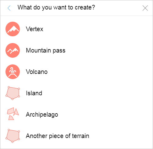
When you create a terrain item, the category selection menu opens:
When you choose a category, the attribute panel for the map item opens:
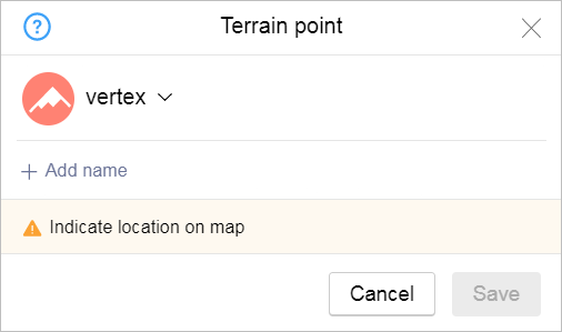
If the item you selected is represented by a placemark (i.e. a vertex, mountain pass, or volcano) the attribute panel for the section of line will look like this:
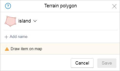
If the item you selected is represented by a polygon (i.e. an island, archipelago, or other such item) the attribute panel for the section of line will look like this:
Rules for adding attributes to these items:
3.11.2.1
-
To add attributes to polygonal items:
-
Select the Type of item from the list (Island / Archipelago / Other terrain item):
-
Island: a piece of land that is surrounded by water on all sides As the island is allowed to render permanent artificial reinforced concrete design used for the arrangement of different structures.
Sections of land that are surrounded by water due to seasonal changes (floods or tides) are not considered islands. These sections of land are not displayed on the map as reservoir shapes or types of terrain.
-
Archipelago: a group of several islands.
-
Other terrain items: terrain items that don't match any of the other types, provided they have their own name or their type is specified. For example, peninsula, cape, desert, quarry, ravine, mountain range, salt marsh, spoil tip. Also assign this type to terrains that are not drawn in the
Administrative division layer
.
-
-
Set the Name of the item as follows:
-
If the type and proper name of the item are known, set the
official
name using the combination [type]+[proper name]. For such items, the namefor caption on map
is not assigned. -
If the item doesn't have a proper name, but does have a type, the
official
name should only include the type (starting with a capital letter). For such items, the namefor caption on map
is not assigned. For example, the official name of an unnamed item of the quarry type can be indicated asQuarry
.
-
-
3.11.2.2
-
When adding attributes to relief point objects:
-
Select the object type from the list: Summit, Mountain Pass, Volcano.
Note
Objects of the Summit type belong to different subtypes, for example
mountains, rocks, or spoil tips, which is reflected in their names (see below).
-
Set the object name as follows (you can include the object height in meters in the name):
-
If the type (subtype), proper name, and height of the object are known, then set the
official
name using the following combination: [proper name]+[type]+[height].Caption
should only include the proper name.For example: the official name is Belukha Mountain 4509 meters, and the name for the caption on the map is Belukha.
-
If the object does not have a proper name, and its type and height are known, then the
official
name is set using the combination [type]+[height], and thecaption
should only include the height value.For example: the official name is Mountain 1157 meters, and the caption on the map is 1157 m.
As an exception, for single items of types that are not typical for a given area (for example, a rock, spoil tip, or hill), it is allowed to specify the type in the name
for the caption
.For example: the official name is Rock 870 meters, and the caption is Rock 870 m.
Note
If a mountain, rock, or hill has multiple unnamed peaks, then the highest one is indicated on the map.
-
If the proper name of the
Summit
item does not contain its geographical type, then for single objects that are not typical for the given (for example, a rock, spoil tip, or hill), it is allowed to specify the subtype in the namefor the caption
.For example: the official name is Rock 870 meters, and the caption is Rock 870 m.
-
If the object does not have a proper name, it is allowed to specify the value of its height both in the
official
name and in thecaption
. For example: the official name is Height 152 meters, and the caption on the map is 152 m. -
If the name and height of the object are unknown, then set the object type as an
official
name in accordance with the general rules for naming unnamed items. In this case don't set the caption for the map.For example: the official name is Volcano, the caption is not set.
-
Note
The height value of the object is always given in meters and rounded to the nearest integer. For example: 269.8 meters → 270 meters, 112.2 meters → 112 meters.
-
3.11.2.3
- Terrain relief items are named in accordance with the rules outlined in section 3.11.2.2 and with the general rules (see 3.1.3. Map item naming rules.