2.4. Create and edit map items
Alert
When you create and edit map items, you must comply with the technical restrictions.
Create a map item
To create a new item on the map:
-
Adjust the scale of the satellite image until the item you want to map is clearly distinguishable.
There are several ways to change the scale.
If the chosen scale isn't suitable for drawing your item, the
Zoom in to edit
message will appear on the map: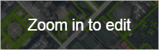
In this case, increase the map scale (until the message disappears).
-
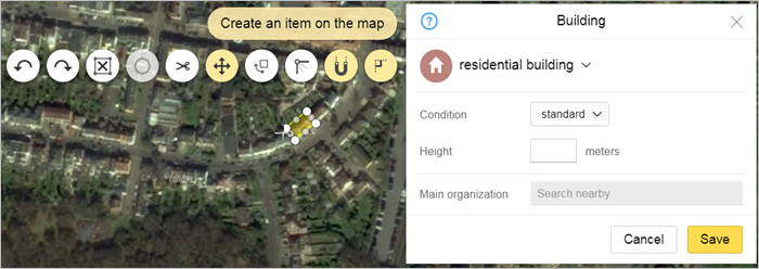
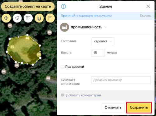
Click Create. The
New item category
menu opens: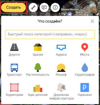
The majority of categories include several types of map items. In this case, when you click buttons in the
New item category
menu, an additional menu will open and you can select your item type there.For example, when you select the
Hydrography
category, an additional menu opens that includes theBody of water
,Area of river bed
andHydrography point
types: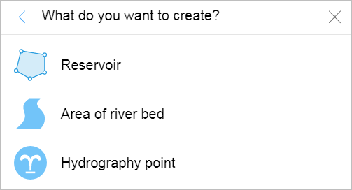
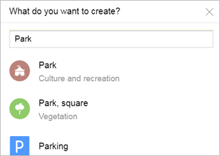
In the upper part of the menu, there is a field where you can quickly search for item types.
Start entering the item's name to see the suggestions of item types and categories:
-
Choose your place type.
When you click the button, the attribute panel for the item opens and your cursor turns into a drawing tool:
-
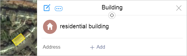
Draw the item on the map and enter values for its attributes (characteristics) in the attribute panel:
-
Drawing an item. There are three types of Yandex Map Editor items (as with any other type of map):
-
Places. These map items display as placemarks (icons). Every type of item has its own icon.
For example, air transport items are represented by these icons:
 — airports;
 — airfields;
 — airport
terminals;
— airport
terminals; — helicopter
pads
— helicopter
pads
Drawing techniques for places are described in the Drawing places section.
-
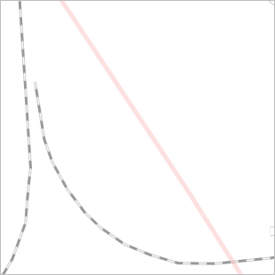
Linear items. These items display on the map as lines. Every type of item has its own type of line. For example, metro lines are pink, railways are black-and-white dotted lines:
Linear features are often too long to render on the map at once. This is why they are usually drawn sequentially:
-
During the first stage, individual sections of a linear item are drawn. For example, these could be sections of a motorway or metro lines.
Drawing techniques for these types of linear items are described in the Drawing linear items section.
-
During the second stage (adding attributes), the sections of the linear item are united. Sections of road are united into one road, sections of a metro line are united into a single metro line, etc.
You can edit linear items that are created this way: add new sections to the item if necessary or exclude sections created earlier from it.
Editing techniques for such composite linear items are described in Section 2.6.2. Composite linear objects.
-
-
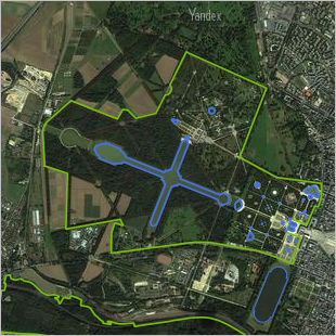
Polygonal items. These items display on the map as polygons (i.e. they encompass a particular area). Every type of map item has its own type of outline and area encompassed by it. For example, reservoirs are represented by blue polygons, vegetation (forests, parks, etc.) — by green ones:
Techniques for working with polygonal items are given in Section 2.7. Polygonal items.
-
-
Adding map item attributes. Techniques for adding attributes are described in Section 2.10.1. The attribution of the object.
Item names for various item types are assigned uniformly. See Section 2.10.1.2. Techniques for naming items.
Attributes for various item types are described in Section 3. Global mapping rules.
-
-
Not all items are "drawn" on the map: some are compiled during editing or added as attributes of existing items. These types of items include:
-
Composite linear items (motorways, railways, rivers, etc.) made up of separate sections. These are created during the process of editing sections of linear items and only later edited as individual items. For more information, see Section 2.6.2. Composite linear objects.
-
Intersections (connections) are the start and end points of linear items (such as road sections) or points where these items meet. They are created automatically. For more information, see Section 2.9. Crossings.
Line intersections are items attached exclusively to items of the same type: roadways or other transport lines. If a roadway intersects a metro line (or in other similar cases), then an
intersection
item is not formed. -
Road signs are not entered as drawings, but as attributes (characteristics) of road intersections. Creating and editing techniques are described in Section 3.3.4. Road signs
-
Speed cameras are not entered as drawings, but as attributes (characteristics) of road intersections. Creating and editing techniques are described in 3.8.3. Speed cameras.
-
Traffic lights are not entered as drawings, but as attributes (characteristics) of road intersections. Creating and editing techniques are described in Section 3.8.4. Traffic lights.
-
-
After the item is created, you must save your changes using one of these methods:
-
Click Save (or press Ctrl + S).
The item and attribute panel will switch to viewing mode.
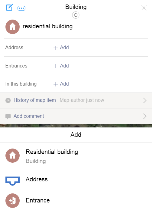
You will see the Add menu, where you can create another item of the same or a different type (for example, after you create an
Industrial zone
type item, you can create anotherIndustrial zone
or something different, like aBuilding
orIndustry
):
-
Press Shift and click Save (or press Shift + Ctrl + A).
The item will be saved, it will no longer be highlighted on the map, and the attribute panel will close. The item creation mode simultaneously activates; this is similar to the previous one (the attribute panel opens and the cursor switches to item drawing mode).
-
Edit a map item
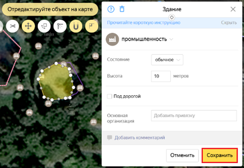
To edit an item that was created earlier on the map:
-
Select the item on the map. When you do this, the item will light up and the attribute panel will open (in viewing mode):
Note
In the editing panel for each map item, there is a Show item on map button:
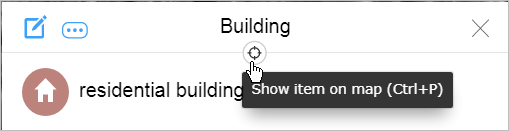
When you click it (or use the Ctrl + P shortcut), the item will be highlighted and the map will center around it.
-
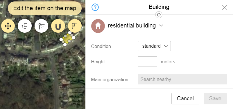
Click Edit
 on the panel (or use
Ctrl + E).
on the panel (or use
Ctrl + E).The item and attribute panel will switch to editing mode:
-
Edit an item: change its shape on the map and/or change the value of one or more attributes.
Alert
Don't use editing tools to create new items by dragging existing ones to the appropriate location and changing their size or attributes (thereby
turning
demolished buildings into new ones, former construction sites into parking, and so on)-
Techniques for editing item shapes of various types are described in these sections:
-
You can make changes to attributes in the attribute panel for the map item. For techniques on how to work with panel fields, see 2.10.1. Attributing items. For the values of item attributes, see the subsections of 3.1. General rule.
-
For techniques for editing composite linear items (roads, railways, and so forth) consisting of separate sections, see 2.6.2. Composite linear objects.
-
Techniques for creating and editing road signs are described in 3.3.4. Road signs
-
-
To save an edited map item, click Save.
-
You can also undo edits and report errors to a moderator.