2.2.3. Change the map scale
There are several options for changing map scale:
- Using the
 and
and  buttons.
 - Using the mouse wheel: roll it towards you to decrease the scale (
zoom out
); roll it away from you to increase the scale (zoom in
). - Using the mouse. Using the mouse button: double-click on the map to increase the scale (
zoom in
); right-click to decrease it (zoom out
). - Using the right mouse button:
-
Use the right mouse button to click a point on the map.
-
Drag the mouse in the desired direction without letting go of the button.
The cursor will then highlight an area on the map.
-
Let go of the button.
The highlighted area will be centered, and the map scale zoomed in.
-
2.2.3.1. Map scale
Map scale: the ratio between the size of an image and the size of the actual item it represents. For example, Scale 1:100 000
means that the image of an item on a map is 100,000 times smaller than the actual item.
Scale is a constant value on printed maps, but it may change on electronic ones.
On Yandex Map Editor, scale is indicated in relative units between 1 and 22. You can see the current scale value in the map's URL (М
value in the z=M
section):
- https://n.maps.yandex.ru/#!/?z=2&ll=56.612180%2C59.847933&l=nk%23sat
- https://n.maps.yandex.ru/#!/?z=12&ll=29.078553%2C53.626574&l=nk%23sat
- https://n.maps.yandex.ru/#!/?z=21&ll=29.054907%2C53.651009&l=nk%23sat
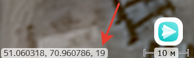
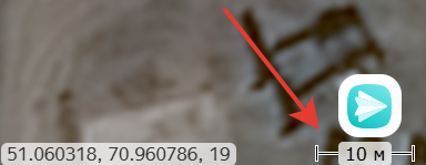
or in the bottom-right corder next to the coordinates of the displayed map's center:
Here are the approximate scale equivalences between Yandex Maps and printed maps
:
- 9 ~ 1:1 000 000
- 12 ~ 1:100 000
- 14 ~ 1:25 000
- 16 ~ 1:10 000
- 17 ~ 1:5 000
You can evaluate the scale of the displayed map by using the scale bar that indicates the length of the corresponding segment on the terrain (in the lower right corner of the map):
The full range of Yandex Maps scales is only available in areas where satellite images of sufficient quality are available.