2.6.1. Simple linear items
This section contains drawing and editing techniques that apply to all simple linear items. It also explains how to undo edits and send error reports about a map item to the moderator. (For example, you can send an error report if an item should be removed from the map but you don't have permission to perform that action.)
This section also contains 2.6.1.1.1. General rules for drawing linear items and describes 2.6.1.1.2. Drawing curves.
2.6.1.1. Simple linear items: drawing techniques
There are general drawing and editing techniques that are used to draw places of various categories.
To start drawing:
Alert
When drawing, follow 2.6.1.1.1. General rules for drawing linear items.
To draw a linear item:
-
Adjust the scale of the satellite image until the item you want to map is clearly distinguishable.
If the current scale is not suitable for drawing the item, a message will appear on the map. In this case, just increase the scale (until the message disappears).
-
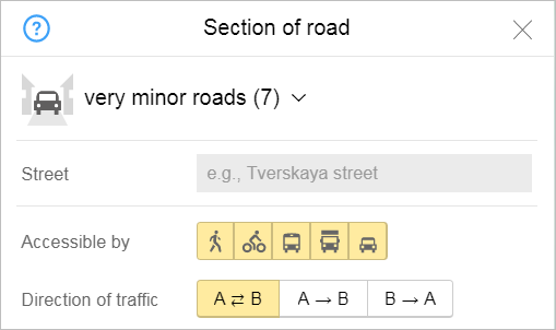
Click Create. Select the appropriate item category from the menu that appears.
For example, Road
 . If the menu of item types opens, select the necessary type.
 -
The corresponding attribute panel will open; for example, Section of road (a partial panel is shown in the drawing).
-
Click once to set the starting point (vertex) of the section.
Note
The starting and ending points that make up the line and the points where the line bends are called vertexes.
On the map, the cursor looks like a
plus sign
in drawing mode. -
Move the cursor to the next vertex of the section (lines between vertexes are dotted), then click on the point and choose an action. Pieces of road between vertexes are solid on the map.
Every vertex appears on the map as a circle.
If the item is not a straight line and you need more than two vertexes to map it, then click on the spots where the line bends to set intermediary vertexes.
In the middle of the two consecutive vertexes you entered, you'll see circular points that you can use to bend the line (see below).
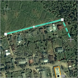
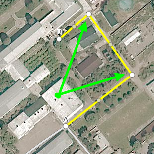
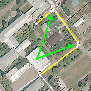
If the beginning and ending points of the line you're drawing are the same, you only have to draw one point. For example, an administrative division border:
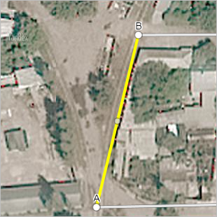
If the beginning and ending points of the line you're drawing are different (i.e. the line has a direction), then the beginning and ending vertexes will automatically be marked
A
(beginning) andB
(ending).For example, the direction of the drawing (A→B) is important for a road section (the direction of traffic permitted on that road is linked to it):
-
To add a new vertex to your segment (for example, to make your drawing more detailed):
- Position your cursor on any intermediary point between the vertexes (on one of the circular dots).
- Click on the dot (the cursor will change to a
hand
). - Drag the point to a new position and it will turn into a new vertex:
-
You can open the context menu when drawing items (the menu differs depending on if you click on a beginning/ending point or one of the intermediary ones):
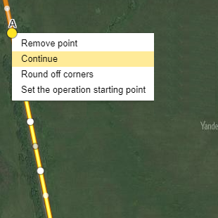
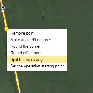
From the context menu, you can perform the following operations:
-
Delete a beginning or ending vertex (from the ones that you drew) and continue drawing the item beginning with the previous vertex. Just click a vertex and select Delete in the context menu.
-
When you Delete any vertex in the middle of a segment, the neighboring vertexes will join together into a straight line. You can straighten out a piece of road this way. Just click a vertex and select Delete in the context menu.
-
Finish drawing a map item. The item will switch to editing mode and your cursor will change back to its typical status. Then you can save the item. Just click a vertex and select Finish in the context menu.
-
Continue drawing an item that was finished earlier. Just select the appropriate vertex in the context menu and click Continue (this only works if you clicked Finish previously).
-
Split a piece of road at the vertex/vertexes that are currently selected. The piece of road will turn into two (or more) separate items. You may need to do this if an attribute value changes for one discrete segment. For example, the surface of a village road might be paved in some areas and dirt in others (see the
Pavement
attribute).Just select the appropriate vertex in the context menu and click Split while saving. The vertex will be marked with the
Scissors
icon ( ). When you save the item, it will split at the vertex you indicated (turning it into two different items). The icon will disappear.
After you perform the command but before you save the item
After saving the item
-
Unsplit an item. For example, if it was split in error (the wrong vertex was selected). Just select the appropriate vertex and click Unsplit in the context menu (this command is available for vertexes where the Split while saving option was previously available).
-
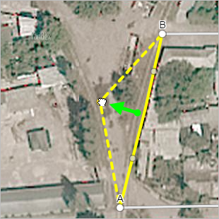
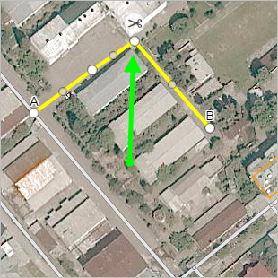
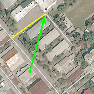
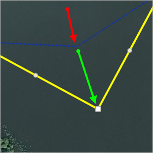
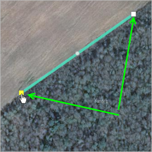
Make angle 90° for an item you drew. Makes the selected angle a right angle (90°). Just select Make angle 90° in the context menu for the appropriate vertex.
In the drawing below, the vertex position before clicking on the command is marked with a red arrow (a section of a water transport line). The green arrow points to the position after you click the command:
-
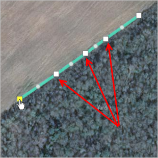
Round the corner: rounds the selected corner (by re-drawing it using several vertexes).
This operation is used, for example, to draw or edit sections of linear hydrographic items and sections of road (in correspondence with point 3.3.1.3.3, you should make road turns round).
To do this, select the appropriate vertex and then click Round corner in the context menu:
Before performing the command
After performing the command
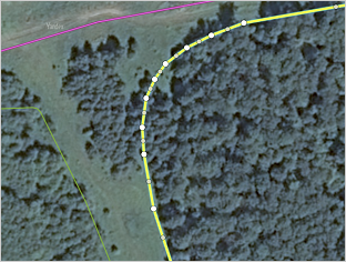
You can also round the corners for all vertexes of a road section or a linear hydrographic item (such as a river or channel). To do that, click Round off corners
 (or press Ctrl+O). This way all bends in the road section or linear hydrographic item will be rounded:
Before performing the operation
After performing the operation
-
-
Save the item you drew by clicking Save in the attribute panel.
If you don't want to save your item, click Cancel in the attribute panel. The item will be deleted.
-
After you draw and save your item, assign attributes to it.
For information on adding attributes, see Section 3.1. General rule.
2.6.1.1.1. General rules for drawing linear items
Sections of an item that are straight lines are drawn using only two vertexes, beginning and ending. Intermediary vertexes are only drawn to fulfill other requirements (for example, if there is an intersection on that section of the road):
|
Correct |
Incorrect |
|
|
|
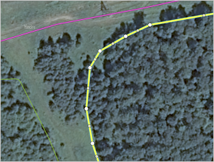
Sections of items that are not straight should be drawn using as few vertexes as possible while maintaining the smoothness of the outline at all map scales (all the way to 18):
|
Correct |
Incorrect |
|
|
|
Note
You can leave sharp corners when drawing ramp turns and mapping pedestrian crossings where they adjoin stairs.
2.6.1.1.2. Drawing curves
When you draw certain items (road sections, tram lines, railway lines, rapid transit or water transport lines, or linear parking), you can use the Drawing curves tool to simplify the process.
Here's how to use it:
-
When you start drawing an item, click Curve drawing mode:
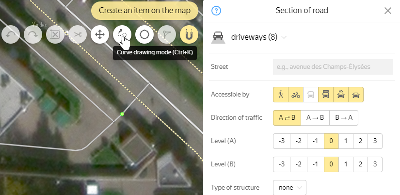
Note
Instead of clicking the Curve drawing mode button, you can use keyboard shortcuts Cmd + K / Ctrl + K before you start drawing.
Pressing the combination again turns off the mode.
-
Click on the item's start and end points. They will be connected by a line (highlighted in yellow):
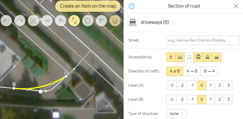
This line can be transformed by moving the nodal points (displayed on the dotted line) using the mouse:

-
When you are happy with the line, clickCurve drawing mode again to turn off the mode.
The curve will be saved in the editing mode, which will allow you to correct its shape and placement:
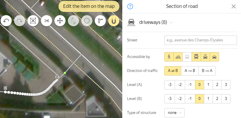
-
Click Save to save your item.
2.6.1.2. Simple linear items: editing techniques
You may have to edit items if, for example, more detailed satellite images become available that let you draw a more accurate outline.
To edit a linear item:
-
Click the item on the map.
-
In the attribute panel that opens, click Edit
 .
.The item and attribute panel will switch to editing mode:
-
When you edit a map item, the following buttons become active:
 — Cancel. Cancels the last operation with that map item. Keyboard shortcut Ctrl + Z.
 — Redo. Repeats the last operation with that map item (in other words, it reverts the item back to its state before you "undid" the last operation). Keyboard shortcut: Ctrl + Y.
 -
Edit the item. You can:
a) Delete a vertex
You can delete a vertex to flatten out an item or make it shorter.
To delete a vertex:
- Click the item on the map.
- Click on the appropriate vertex to open the context menu. Then click Delete.
- The vertex will be deleted. If the vertex is not a beginning or ending point, then the neighboring vertexes will join together to form a straight line.
- Click Save in the attribute panel. Your changes will be saved.
b) Move a vertex
You can move a vertex to correct your drawing of an item.
To move a vertex:
- Click the item on the map.
- Click on the appropriate vertex and your cursor will change to a
hand
. Then move the vertex to its new position. - Click Save in the attribute panel. Your changes will be saved.
c) Add a vertex
You can add a vertex to correct your drawing of an item.
To add a vertex:
- Click the item on the map.
- Click on the intermediary point (the circle-placemark) between two neighboring vertexes and your cursor will change to a
hand
. Then move the vertex to its new position. The point you move will turn into a new vertex. - Click Save in the attribute panel. Your changes will be saved.
d) Split an item
You can split an item if you need to add an attribute like a lifting gate (see section 3.3.1.7. Rules for drawing road barriers) or video cameras (see 3.8.3. Speed cameras
To split an item:
- Click the item on the map.
- Click on the appropriate vertex to open the context menu. Select the Split before saving command. The vertex will be marked with the Scissors icon.
- Click Save in the attribute panel. You changes will be saved (the item will split at the point you selected).
To rejoin the item (before saving your changes): click on the vertex marked with a
Scissors
to open the context menu. Then select Unsplit.e) Make an angle 90°
Making an angle 90° means that any bend in a line will transform into a right (90°) angle.
To create a right angle:
- Click the item on the map.
- Click on the vertex that needs to be straightened to open the context menu. Then select Make angle 90°. This will make it a right angle.
- Click Save in the attribute panel. Your changes will be saved.
f) Round a corner
Rounding a corner means that any bend in a line that is drawn using one vertex will transform into a rounded corner made up of three vertexes.
To round a corner:
- Click the item on the map.
- Click on the vertex that needs to be rounded to open the context menu. Then select Round the corner. The corner will be rounded.
- Click Save in the attribute panel. Your changes will be saved.
g) Round all corners
Rounding all the corners works the same as rounding one, but the operation applies to all corners along non-straight lines: corners that are drawn using one vertex are transformed into rounded corners (drawn using three vertexes).
To round all corners of an item:
- Click the item on the map.
- Click on any of vertexes to open the context menu. Select Round off corners. All corners will get rounded.
- Click Save in the attribute panel. Your changes will be saved.
h) Straighten a line segment
To straighten a line segment between two vertices (removing all vertices between the first and last vertices of the segment being straightened):
-
Select the item on the map. The attribute panel for the map item opens.
-
In the attribute panel that opens, click Edit
.The item and attribute panel will switch to editing mode:
-
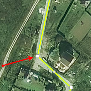
Click the first vertex of the line segment you plan to straighten and select Set the operation starting point in the context menu that opens:
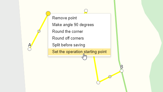
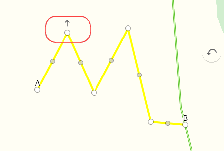
The selected vertex will be marked with an arrow:
-
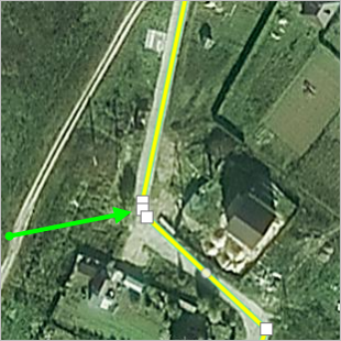
Click the last vertex of the line segment you plan to straighten and select Straighten from the starting point to the current point in the context menu that opens:
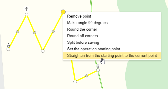
The line between the first and last vertices of the segment will be straightened, and the vertices between them will be deleted:

-
Click Save. Your changes will be saved.
2.6.1.3. Undoing edits and sending error reports Delete a map item
With simple linear items, you can also undo edits and send error reports about items to the moderator. These operations are used to delete map items.