View an object description
In an object card, you can see detailed information about a place (geographical object), organization, or public transport stop.
Business owners can manage their organization's profile. See Yandex Business Help for details:
-
Quick start — add your organization to Yandex Maps.
-
Fill out the company information — edit your organization's profile data.
Open a card
For an organization
- Tap the name of the organization.
- Pull the card up to see the details.
For a place
- Tap and hold a map point.
- Select one of the following See what's here.
- Pull the card up to see the details.
- Enter the place name or address in the search bar.
- Select a place in the search results.
- Pull the card up.
Share a card
-
Tap
 and select the service or messenger you want to use to share a link to the place card.
 -
Tap and hold the place name to copy it or share a link to the object card.
-
Touch and hold the organization's address to:
- Copy the address or coordinates.
- Share a link to the object card.
Organization card
Each organization marked on the map has its own card. It contains:
-
Name and category of the organization.
-
User reviews and rating of the organization. Tap them to see all reviews about the organization.
Yandex Maps may display a translation if the review language is different from your interface language. Tap the language name below the review to see the original text.
You can add your own rating and review. At the top, you'll see reviews from the users that you follow.
If a user you follow reviews an organization, the card will display a notification about it.
Use filters and sorting to see the reviews on a topic that interests you.
To share your feedback, tap .
-
Awards: If an organization has a high rating and many positive reviews, it's awarded the "Good place" badge. There are other awards too, such as Ultima Guide.
-
About the place: Tap to view a brief description of the organization in story format. Yandex Maps generates these descriptions using information from organization owners, user reviews, photos, and videos. This option is available for select organizations.
-
Business hours: Tap to see the full information on the organization's working hours.
-
Distance and travel time from your location to the organization.
-
Buttons:
- Directions — Plot a route to the organization.
 — Call the organization.
- — Share a link to the organization.
 — Save the organization to saved places.
 — Go to the organization's website.
-
Photos. To view full-size photos and videos, tap the file thumbnail at the top of the card or in the gallery on the Photos tab. To move between photos, swipe right or left. You can share or report both photos and videos, but saving and liking are only supported for photos.
-
Address: Organization's address. To view the entrances, tap Show entrances.
-
Contact info: Phone numbers, website links, and social networks.
-
Edit info or Incorrect information: Tap to edit information if the organization card description contains incorrect info.
-
Directions: View the list of the nearest public transport stops, metro stations, and the distance to them from the organization. To build a route to an organization from a specific stop, tap the stop's icon.
-
Show parking info: Tap to find parking near the organization.
-
Businesses in this building or What's inside: If there are other organizations inside the facility (for example, within a shopping mall, airport, or park). To view all organizations in an object or add a new one, tap Show all.
-
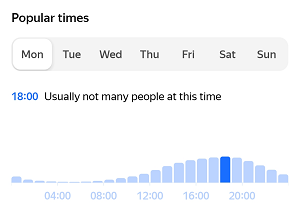
Popular times: See how busy it gets at your chosen day and time on the chart.
What the chart looks like
-
News: If the organization announces events.
-
Branches: If the organization has branches.
Place card
If there are no organizations at the selected point, a place card opens. It contains:
-
Name. If the selected location doesn't have a name, the card will display the name of the administrative division to which the location belongs. For example, if you select a point outside a building on the map, you may be shown the name of the street or neighborhood.
-
Coordinates of the selected location.
-
Distance and travel time from your location to the selected location.
-
Buttons:
- Directions: Plot a route to the place.
- : Share a link to the place.
- : Add the place to your saved places.
-
Photos. To view full-size photos and videos, tap the file thumbnail at the top of the card or in the gallery on the Photos tab. To move between photos, swipe right or left. You can share or report both photos and videos, but saving and liking are only supported for photos.
-
Businesses in this building: If there are any inside the object.
-
Show entrances — displays building entrances:
 , when the selected point is part of that building.
 -
Directions: With a list of nearby public transit stops, subway stations, and their distances from the selected place. To build a route to a place from a specific stop, tap the stop's icon.
-
Add item to map: Tap to add an object that was not found on the map.
-
Edit building info or Incorrect information: Tap to edit information if the place card contains an inaccuracy.